

IW:LEARN MANUALS
5. Best practice in MPA, ICM, MSP, and the use of fisheries refugia tools/elements and recommendations for inclusion into the strategic approach.
View chaptersChapters
2. The ecosystem-based 5-module approach and recommendations for strengthening the approach
3. The strategic importance of TDAs, SAPs and NAPs and recommendations for areas where these can be strengthened
5. Best practice in MPA, ICM, MSP, and the use of fisheries refugia tools/elements and recommendations for inclusion into the strategic approach.
In addition to the support of LMEs, the GEF works at other scales, such as providing support for ICM at community and river basin scale, to promote sustainable use and habitat protection (Sherman et. al. 2009). The first operational strategy for IW in 1995 identified the importance of ICM and MPAs. From that time, ICM and MPA projects have been eligible for GEF funding through the GEF IW portfolio.
Many TDAs and SAPs in LMEs have incorporated the use of closely related spatial or species based instruments to assist the improvement of management and governance of LMEs. Some of the approaches used in conjunction with the LME approach have included: The Ecosystem Based Management Approach (EBM); An Ecosystem Based Approach to Fisheries (EAF); ICM; MSP; MPAs and fisheries refugia.
The use of some of these tools in completed SAPs to date has recently been reviewed (Table 1), including:
•SAPs for 8 LMEs plus PEMSEA emphasise or include ICM measures and activities,
•The relatively new approach of Marine Spatial Planning has been emphasized in few SAPs; the Red Sea, PEMSEA (ICM zoning), SAPPHIRE and CLME+,
•6 SAPs include specific measures for creating or strengthening Marine Protected Areas, and
•The SCS+GT SAP includes a special emphasis with targets and deadlines for fisheries refugia / community run temporary closures for fisheries.
Table 1: LME management strategies for SAP implementation (from UNDP 2017)
|
No. of SAPs |
Frequency |
|
|
Cost-Benefit Analysis of overall EBM approach and/or Value Chain Analysis for specific sectors (e.g. specific fisheries) to justify political support to EBM approach |
16 |
89% |
|
Identification and adoption of management areas for maintenance of biodiversity and related goods and services, including marine and coastal connectivity |
16 |
89% |
|
Adoption of an effective EAF for the management of living marine resources & fisheries focusing on food security |
14 |
78% |
|
Overall regional interaction and coordination on EBM and EAF issues |
14 |
78% |
|
National and Region-wide standard application of successful procedures and tools such as EIA, SEA, ICM, MSP, GIS in the transboundary context |
14 |
78% |
|
National adoption of an EBM and EAF approach with associated effective monitoring and enforcement |
12 |
67% |
|
Development of a regional network of connected MPAs and EBSAs |
10 |
56% |
|
Adoption of new ‘best practice’ cost-effective technologies to address threats and impacts to the ecosystem |
9 |
50% |
|
Improvements in mariculture techniques to reduce pressure on LMRs and the ecosystem |
8 |
44% |
|
Restoration of natural ecosystem processes (e.g. within watersheds, mangrove restoration, artificial coral propagation, etc.) |
8 |
44% |
Programming separate projects across one region (as in the example of Vietnam) is an approach that has been used in some LME regions, but the preferable approach would be to ensure that the LME approach is more strategic from the start, includes adjacent rivers and inshore coastal regions and includes hotspot or national activities such as MPAs, ICM and fisheries refugia as local demonstrations in regional LME projects.
An example of action at provincial and municipal scale is the GEF-funded UNDP-supported Partnerships in Environmental Management for the Seas of East Asia (PEMSEA) program with its focus on ICM. ICM tools can be used in a manner similar to the LME approach but at local scale, by increasing awareness of the importance of ecosystem services and values, encouraging private sector involvement and multi-sectoral management (Sherman et. al. 2009).
A good example linking LMEs, ICM and MPAs is the Gulf of Aqaba IW Project in the Red Sea LME. A transboundary marine park was established with World Bank and GEF support. The Aqaba Development authority for ICM was adopted and operationalized to sustain the MPA (Duda 2016). The project helped Jordan to operationalize the Aqaba development Authority for ICM in support of the MPA, protecting an area of sensitive reefs within the Red Sea LME. (Duda 2014).
The UNDP Ecosystems and Biodiversity (EBD) Programme supports projects for biodiversity management and sustainable development in costal and marine regions. Thirty five countries are beneficiaries, among them 7 LDCs and 10 SIDS. Interventions include the establishment, strengthening and financing of MPAs, integration of biodiversity management measures into other sectors (such as fisheries), the application of ecosystem-based adaptation in critical coastal habitats (mangroves, coral reefs), the sustainable livelihoods of coastal communities (incorporating payment for ecosystem services and microgrants).
5.1 The Ecosystem Based Management Approach
The geographic LME approach was itself designed to be a vehicle for operationalizing the Ecosystem Based Management (EBM) approach, with area large enough to address transboundary considerations (Duda 2016). The five-module approach for LME assessment is premised on the need for an EBM approach to LMEs, that is inclusive of all the ecological parameters as well as the human dimension. Ecosystem-based management provides a framework for the integration of these and other strategies to improve efficiencies and better management of ecosystems.
Single-approach strategies, that might include single-species fisheries management, MPA network development, climate change adaptation measures or pollution / invasive species management measures can be very useful tools, and make significant contributions to protection of ecosystems. However, a lack of integration with other strategies can lead to challenges in implementation and potential conflict between sectors and approaches.
A description of EBM is that it: “emphasizes the protection of ecosystem structure, functioning and key processes; is place-based in focusing on a specific ecosystem and the range of activities affecting it; explicitly accounts for the interconnectedness among systems, such as between air, land and sea; and integrates ecological, social, economic and institutional perspectives, recognizing their strong interdependences.” (Bensted-Smith and Kirkman 2010).
NOAA provides a very useful tool for understanding EBM:
http://ecosystems.noaa.gov/EBM101/WhatisEcosystem-BasedManagement.aspx
It describes EBM as having the following core characteristics:
•Adaptive and flexible, responsive to monitoring and research results,
•Place-based with geographic areas defined by ecological criteria,
•Cross-sectoral, considering interactions between sectors of human activity,
•Proactive, incorporating tradeoffs to manage the marine and coastal environments, and
•Inclusive and collaborative, encourages participation from all levels of government, indigenous peoples, stakeholders.
UN Environment’s proposes the step by step process for moving towards EBM. It outlines the following steps for implementing marine and coastal EBM:
1Making the case for marine and coastal EBM,
2Examining the core elements of EBM, and
3Moving towards EBM
The guidelines cover the full EBM process, from establishing a foundation, to charting the EBM process, and to applying and adapting EBM.
5.2 An Ecosystem Based Approach to Fisheries
Ecosystem Based Fisheries Management (EBFM) is an approach to fisheries management that puts the health of the ecosystem as a priority, rather than that of the target species. Traditional fisheries practices aim to maximize the catch of a single species, ignoring habitat, prey, predators of the target species and other ecosystem interactions. Unintended consequences of fishing may include habitat destruction, incidental mortality of non-target species, evolutionary shifts in population demographics, and changes in the structure and functioning of ecosystems.
Global discards in commercial fisheries were estimated at 27 million metric tons in 1997, which was then estimated at one fourth of the world’s fish catch. Ecosystem based fisheries management seeks also to reduce global bycatch, through the introduction of ocean zoning and also the development and deployment of less damaging fishing technologies.
In particular, EBFM seeks to:
1avoid degradation of ecosystems, as measured by indicators of environmental quality and system status,
2minimize the risk of irreversible change to natural assemblages of species and ecosystem processes,
3obtain and maintain long-term socioeconomic benefits without compromising the ecosystem, and
4generate knowledge of ecosystem processes sufficient to understand the likely consequences of human actions. (Pikitch et. al. 2004)
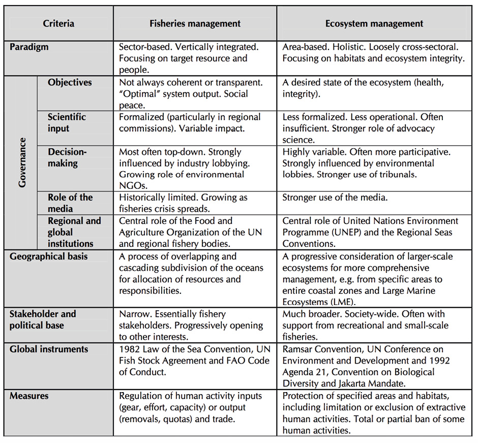
Similarly, an Ecosystem Approach to Fisheries (EAF) is a holistic strategy for managing capture fisheries so that ecological, socio-economic and institutional dimensions are integrated (see Table 2). The EAF attempts to:
•reduce ecosystem effects of fishing on associated or dependent species such as predator or prey of the target fishery,
•reduce impacts of fishing gear on the environment,
•to improve selectivity and thus reduce bycatch and discards, as well as to, and
•reduce gear loss and ghost fishing.
The EAF Management Cycle (Figure 2) addresses:
1Initiation and planning
2Identify and prioritise issues
3Develop management system
4Implement and monitor
EAF planning and implementation may be at different time scales; for example one year for tactical, and 5-10 years for medium to long term planning and implementation (Bianchi et. al. 2016). The ecosystem approach to fisheries is well described in FAO Fisheries Technical Paper No 443 (Garcia et.al. 2003).
In those LMEs where fisheries are not sustainable, EAF planning and implementation is a valuable tool for dealing with fisheries issues within the LME EBM framework. This process has been adopted in the BCLME, BOBLME, CCLME and CLME where EAF is being implemented in the shrimp and ground fish fisheries. The “issue identification” step of EAF can be equated to the same step in the TDA process (Bianchi et. al. 2016).
In some cases it has been difficult to involve Regional Fisheries Bodies (RFBs) in the work of LMEs unless it was deliberately planned with FAO, but this has been shown to work in the cases of CCLME, GCLME, CLME+ and BOBLME at least (Duda 2014).
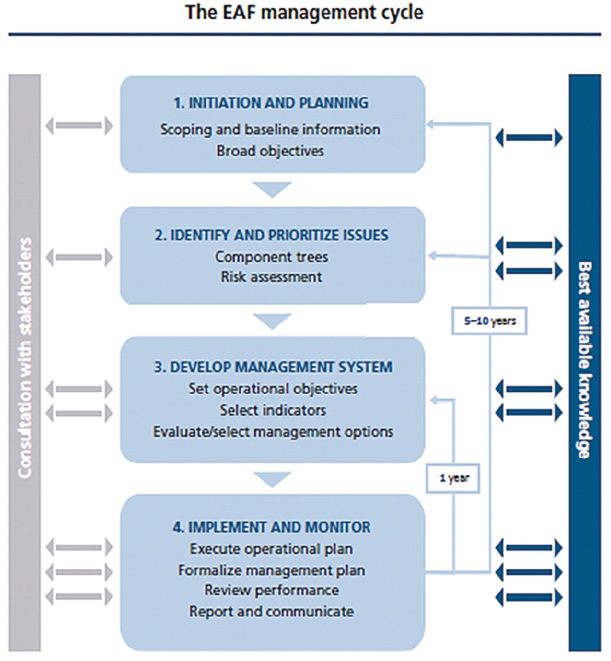
Figure 2. The EAF Management Cycle (Bianchi et. al. 2016)
The FAO Code of Conduct for Responsible Fisheries (1995) contains provisions for many aspects of the EAF, in particular calling for a management approach to fisheries that gives more attention to the ecosystem. The Code provides a synthesis of a number of binding and voluntary arrangements, agreements, conventions etc. of direct and indirect relevance to fisheries, to increase the sustainable contribution of fisheries to development. The term “Ecosystem Approach to Fisheries” was adopted by the FAO Technical Consultation on Ecosystem- based Fisheries Management in 2002, as a term that would not be limited narrowly to management, could easily cover also development, planning, food safety, etc., thus better matching the breadth of the FAO Code of Conduct (Garcia et.al. 2003).
Unsustainable fishing practices have resulted in close to 30% of fish stocks being overexploited or collapsed, within LMEs (GEF LME:Learn 2017). Thus, the inclusion of sustainable fishing management measures is essential in many SAPs. The EAF has been incorporated into the fisheries components of several LME projects.
In the Benguela Current LME, for example, the FAO has supported the BCC through its involvement in fisheries surveys and the implementation of an EAF in the region. The EAF Nansen Programme has also provided long term support to the three participating countries, through fisheries surveys and EAF training courses. WWF has also promoted EAF in the BCC region through establishing baselines for tracking EAF in the three participating countries and mobilizing the human dimension of EAF. WWF’s Responsible Fishing Training Programme has been implemented in Namibia in partnership between the BCC and Namibian Fisheries Institute.
Table 2: A schematic comparison of traditional fisheries vs ecosystem based management (in Garcia et. al. 2003)
The Bay of Bengal LME Project, together with NOA) and the Coral Triangle Support Partnership (CTSP), funded by the U.S. Agency for International Development (USAID), the FAO, and the Asia Pacific Fishery Commission (APFIC) developed very useful tools for EAF, including a training course and toolkit on the ecosystem approach to fisheries management, specific to the needs of the Asia-Pacific region.
In the Bay of Bengal LME, eight countries have provided fisheries advisories for hillsa and shad or Indian mackerel, that incorporated the ecosystem approach. Advisories were produced by a Regional Fisheries Management Advisory committee which received information from technical working groups. Together with partners APFIC, the Coral Triangle Initiative (CTI), USAID and NOAA developed a one-week training course on EAF (Essential ecosystem approach to fisheries management) which consists of 18 modules addressing EAF (Bianchi et. al. 2016)
►The Essential EAFM Handbook (Staples et. al. 2014)
The FAO has developed the EAF toolbox, which guides users through the four main EAF planning steps
and activities. The toolbox aims to assist the choice of tool according to fishery type, resources and capacity.
►www.fao.org/fishery/eaf-net/toolbox/en
The Nansen Programme, now operating as the EAF-Nansen Project, has been instrumental in assisting fisheries projects in Africa for many decades. The Nansen Programme has collaborated with the Agulhas and Somali Currents LME (ASCLME) Project, the Benguela Current LME (BCLME) Project and its successor the Benguela Current Commission (BCC) as well as the Canary Current LME (CCLME) Project and the Guinea Current LME (GCLME) Project. In South Asia, the Nansen Programme has also collaborated with the Bay of Bengal LME (BoBLME) Project.
From 2007 when the EAF-Nansen project became fully functional, a partnership agreement was signed with the LME projects under implementation, namely ASCLME, GCLME and also the Interim Benguela Current Commission (BCC). The CCLME project came on line a few years later. The partnership agreements specified collaboration in various areas:
The Project collaborated with the BCC for example, to implement the following projects:
•○ Implementing a process which allows the view (auditing) and tracking of EAF in management (also known as the Tracking Tool project),
•○ Guidance on institutional arrangements which support EAF, and
•○ Integrating the human dimension of EAF into fisheries management in the BCC region.
The Tracking Tool project was intended to adapt the FAO/WWF-South Africa EAF Tracking Tool for use in the three countries in the BCC area and to build the capacity of scientists and managers in all three countries and particularly in Angola in Ecological Risk Assessment (ERA) methodology and practice, and the use of the tracking tool, to be able to participate fully in the project. Another objective was to assess progress made in implementing an EAF in the region through periodic ERA reviews.
The project was considered a success, and the approach was used to establish EAF implementation baselines in the ASCLME, CCLME and GCLME. the EAF-Nansen Project also collaborated with the South West Indian Ocean Fisheries Project (SWIOFP), which is one of three projects in the ASCLME programme, to assist each ASCLME country, except Somalia and South Africa, both technically and financially to prepare an EAF management plan for at least one fishery.
Fisheries governance frameworks at the sectoral level (including the Ecosystem Approach to Fisheries) must be linked to broader governance frameworks (such as EBM); this has been successfully demonstrated in some LME Projects such as the BOBLME and the Caribbean LME (Bianchi et. al. 2016).
BOBLME and the CLME have explicitly incorporated EAF into SAPs.
5.3 Integrated Coastal Management (ICM)
Integrated Coastal Management (ICM) or Integrated Coastal Zone Management (ICZM), is a cyclical process that aims to build increasingly effective and resilient governance. ICM programs tend to be planned over 15-20 year periods, longer than donor-funded projects tend to last. Management and conservation goals are usually set by governance agencies and local stakeholders together - depending on national priorities and policies. Geographic boundaries tend to be set by stakeholders and authorities, and are not pre-determined by biogeographic considerations.
The term Integrated Coastal Management was first used in 1992 during the Earth Summit in Rio de Janiero. A widely- used definition is “a continuous and dynamic process, which unites government and the community, science and management, sectoral and public interests in preparing and implementing an integrated plan for the protection and development of coastal ecosystems and resources” (GESAMP 1996). ICM is essentially a set of principles guiding a participatory approach for integrating environmental, economic, social, cultural and recreational objectives (a methodology for conservation and development that can be applied in any programme or region).
Defining features of Integrated Coastal Management are that:
•It is a cyclical process that aims to build effective, equitable and sustainable governance through successive cycles of intervention and learning,
•Conservation and development goals to be attained are defined by stakeholders and relevant authorities, and will be dependent on values and national policies, and
•The geographic boundaries of the ICM programme are defined and refined by the stakeholders and relevant authorities, and are not determined by biogeographic considerations. The programme area is generally one where the interests of stakeholders overlap, and where there is a need to introduce or improve inclusive, sustainable management.
Objectives of ICZM (according to the ICZM protocol to the Barcelona convention) are to:
•Facilitate, through the rational planning of activities, the sustainable development of coastal zones by ensuring that the environment and landscapes are taken into account in harmony with economic, social and cultural development,
•Preserve coastal zones for the benefit of current and future generations,
•Ensure the sustainable use of natural resources, particularly with regard to water use,
•Ensure preservation of the integrity of coastal ecosystems, landscapes and geomorphology,
•Prevent and/or reduce the effects of natural hazards and in particular of climate change, which can be induced by natural or human activities, and
•Achieve coherence between public and private initiatives and between all decisions by the public authorities, at the national, regional and local levels, which affect the use of the coastal zone.
Sorensen (2000) estimates that 345 ICM projects have been implemented in 95 coastal countries / states, of which 70 were developing nations. Most ICM project have been small-scale projects, driven by a need for inter-sectoral coordination in a specific, small area - an MPA, a port, island or a section of a coast. ICM/ICZM varies considerably in size, from country-wide (as in the example of Bangladesh), to the size of a municipality (Chonburi, Thailand and Xiamen, China). The development of ICM programs has largely been driven by the threats posed by coastal or land-based issues such as tourism, inshore pollution, and competing demands on the coast. Fisheries are often not well represented in ICM projects (Bensted-Smith and Kirkman 2010).
Up to 2012, the GEF had invested $126 million USD in 32 ICM projects around the world, including in the seas of east Asia, Mediterranean Sea and the West Bering Sea. Some interesting examples include:
•The Pacific Integrated Water Resources Management (IWRM) project had an emphasis on freshwater drainages and aquifer linkages to coastal areas. The emphasis was on the impacts of land-based activities that have the potential to degrade coastal areas, and the importance of ridge-to-reef approaches that start on land, to understand land-based impacts on LMEs, and
•Integrated Watershed and Coastal Areas Management (IWCAM) is one successful example in the Caribbean SIDS.
Developing ICZM/ICM protocols to add to regional seas Conventions has been one way to incorporate new mechanisms for management and governance of the coastal zone via national and local ICM implementation. The Mediterranean region was the first to successfully introduce an ICZM protocol to a Regional Seas framework. The Strategic Partnership for the Mediterranean LME (MedPartnership) project supported countries for implementation of the Protocol through capacity building, aquifer management and 13 demonstration projects. The transfer of environmentally sound technology (TEST) was implemented in 43 industries to reduce pollution loads and improve water productivity. Support for a more effective network of MPAs (through capacity building and demonstration projects) led to Libya establishing its first MPA, and to Management plans for MPAs being drafted by Croatia, Algeria and Turkey (IW: Learn). In addition, the UNEP GEF project MED Integration of Climatic Variability and Change into National Strategies to implement the ICZM Protocol in the Mediterranean had a focus on assisting countries to better understand climate change concerns, integrated into ICZM planning.
Over the past two decades, ICM has been applied in many sites across East Asia, covering more than 31,000 km of coastline and benefiting tens of millions of people in coastal areas. Partnerships in Environmental Management for the Seas of East Asia (PEMSEA), is of particular note as an example of a regional portfolio of ICM projects. Its geographic coverage includes the six sub-regional seas of the East Asian region. PEMSEA’s combination of site- specific projects with regional networking, rather than hierarchical governance, has proven to be very effective (Thia-Eng 2006). Examples of demonstration projects in the PEMSEA region are:
Pollution reduction and waste management in Xiamen, China
•Three cycles of ICM implementation supported better acess to the beaches and sea, plus improving the cleanliness and health of the coastal environment.
Food security and livelihood management in Chonburi, Thailand
•ICM implementation aimed at the sustainable management of blue swimming crabs. A demonstration project was started in the Sriracha municipality in 2006, and since applied in seven additional municipalities, with a marked increase in catches (94% increase 2011 to 2012.
Water use and supply management in Preah Sihanouk Province, Cambodia
•A five-hectare freshwater reservoir was rehabilitated, benefiting over 5000 people in the local area through improved access to potable water for domestic and agricultural use.
•Improved weather resources reduced annual water expenses for small scale business by an average of 30%.
Habitat protection, restoration and management in Batangas, Philippines
•14 coastal municipalities and stakeholders established a network of MPAs to manage and protect fisheries resources, coral reefs, seagrass beds and mangroves. Residents benefited from increased catches and the return of economically important fish species.
Natural and man-made hazard prevention and management in Danang, Vietnam
•An ICM programme in the Danang region focused on measures to strengthen resilience to climate change, including natural buffers against storm surges, improved forecasting and early warning, response and recovery measures. 6.5 KM of dykes were strengthened as a barrier to saltwater intrusion, saving more than 400 hectares of agricultural land. (Thia-Eng 2016)
While demonstration projects were supported in seven of the PEMSEA LMEs (focused on ICM, spatial management in terms of zoning, and inclusion of MPAs) work at a larger, LME-wide scale was supported in four of the seven individual LMEs (SCS + GT, YSLME, ATSEA -Indonesian Seas LME, and Sulu-Celebes LME).
In the Western Indian Ocean, the GEF funded, UN Environment implemented Project Addressing Land-based Impacts on the Coastal Zone (WIO-LaB) supported the development of an ICZM Protocol to the Nairobi Convention. In 2006, the Regional Program for the Sustainable Management of the Coastal Zones of the Countries of the Indian Ocean Project (ReCoMaP) was initiated to strengthen the regional ICZM capacity in the counties of the Western Indian Ocean. The project was implemented by the Indian Ocean Commission (COI) and the European Union (EU), and it assisted in the development of national ICZM strategies in Comoros, Seychelles, Mauritius, Madagascar, Kenya and Somalia. The project also encouraged the development of a regional protocol under the Nairobi Convention (Bille and Rochette 2010). The chief success of the ReCoMaP project was in building the consensus needed among the parties of the Nairobi Convention, to begin the process of developing a regional framework (Martin 2014).
5.4 Marine Spatial Planning (MSP)
Marine Spatial Planning or Maritime Spatial Planning (MSP), has been defined as: “a public process of analyzing and allocating the spatial and temporal distribution of human activities in marine areas to achieve ecological, economic, and social objectives that are usually specified through a political process” (Ehler and Douvere 2009).
The IOC/UNESCO has developed excellent guidance material on MSP (Ehler and Douvere 2009, Ehler 2014) which sets out the 10-step approach for MSP, outlining steps and tasks for undertaking Marine Spatial Planning in generic terms. It incorporates best practice, what has worked or not worked in MSP initiatives around the world.
Key characteristics of effective marine spatial plans are that they are:
•Ecosystem-based, balancing ecological, economic, and social goals and objectives toward sustainable development,
•Integrated, across sectors and agencies, and among levels of government,
•Place-based or area-based,
•Adaptive, capable of learning from experience,
•Strategic and anticipatory, focused on the long-term, and
•Participatory, stakeholders actively involved in the process.
As of 2017, 45 marine spatial plans had been approved around the world, and 65 are starting or planned. (Ehler pers comm. 2017)
The CBD and GEF-STAP Report (2012) reviews MSP around the world, and identifies good lessons from implementation in various projects and should be used as a reference.
There is much room for the two concepts, ICM and MSP, to be better harmonized so that planning and management on the coasts can be integrated with adjacent river systems and spatial planning in the marine realm out to the extents of the EEZ. Many countries have set up effective ICM committees at national or local level, and these should be brought in to the MSP process which is still only starting to be implemented in many countries.
Ocean-based industries are expected to double their contribution to global value by 2030. Growth projections include:
•Marine aquaculture to triple,
•Industrial-scale capture fisheries to more than double,
•Maritime and coastal tourism to double,
•Port activities to more than double, and
•Offshore wind to grow by a factor of 80 (albeit from a small base) (OECD 2016).
Pressures on marine ecosystems, demand for ocean space, and areas for potential conflict are thus likely to grow. (OECD 2017).
The LME approach should take into account the fact that many countries have begun or are planning MSP exercises. As a tool for optimizing the use of ocean space, MSP is and should be complementary to the LME approach. Two clear points of mutual benefit between the processes are that IMCs set up to support the TDA process at national level can be used for the multi-sectoral MSP process, and vice versa. If the TDA process is already commencing, but the MSP is yet on the horizon, the TDA or NDA can attempt to make sure that all sectors are covered and that information collection also covers reviews of available spatial data that can feed into the MSP process at a later stage.
An MSP process, while often driven at national or sub-national level, can be a lever / tool to drive NAPs or part thereof. MSP should certainly be considered as one of the instruments that could be supported or promoted by the SAP implementation project, and implemented in pilot transboundary regions or by participating countries at national level.
The SAP implementation projects in the Agulhas and Somali LME region have identified the regional need for supporting MSP processes. As such, the SAPPHIRE Project ProDoc (inception in late 2017) includes outputs:
•Outputs from Marine Spatial planning process adopted as part of effective management and governance mechanisms, and implemented where feasible,
•Marine Spatial Planning capacity developed and techniques enhanced to support and guide the designation of management areas as part of a dynamic management process (with a focus on zoning of marine coastal areas and development of community management frameworks for those zones – to link in with development of LED plans where possible and appropriate), and
•Strengthen capacity for communities to engage in participatory Marine Spatial Planning and associated management.
Angola, Namibia and South Africa in the BCLME region have jointly committed to the use of MSP for the spatial planning and management of ocean space. Technical support from GIZ and project support from the MARISMA Project (Benguela Current Spatial Management and Governance Project) has assisted the MSP process in the three countries.
Two useful tools developed by the IOC/UNESCO are:
►MSP, a step-by-step approach (Ehler and Douvere 2009)
►Guide for evaluating MSPs (Ehler 2014)
Pinarbasi (et. al. 2017) reviewed tools currently available for Marine Spatial Planning. Thirty four tools were identified in 28 different MSP initiatives, with different purposes, levels of usage and complexity. Many of the tools listed in databases were conceptual and not used in real MSP implementation, and the need for improving functionality, stability and ease of use was highlighted in the report. Most of the decision support tools were used by planners, and the greatest application was for site identification, closely followed by communication, assessment of environmental impact and conflict analysis. Tools being used most often were Marxan (9 uses), and Seasketch (8 uses). The matrix of tools used, and the processes for which they were used may be found in N http://dst.azti.es/matrix/
The Center for Ocean Solutions has developed a guide for selecting appropriate tools for MSP.
►Decision Guide: Selecting Decision Support Tools for Marine Spatial Planning (Center for Ocean Solutions 2011)
Jointly implemented by the Abidjan Convention Secretariat and GRID-Arendal, the Mami Wata Project (Enhancing Marine Management in West Africa through Training and application) has developed tools to assist the countries of the African Atlantic Coast, covering the three LMEs: BCLME, GCLME and CCLME, to undertake MSP.
►https://mamiwataproject.org/tools/ (pending finalization of tools location soon)
Please refer also to the Marine Spatial Planning Toolkit, focusing on MSP at transboundary scale.
Although there is no one single definition, the IUCN defines Marine Protected Area (MPA) as “a clearly defined geographical space, recognised, dedicated and managed, through legal or other effective means, to achieve the long-term conservation of nature with associated ecosystem services and culturalvalues”. MPAs are one of the policy instruments that are available to help ensure the conservation and sustainable use of vulnerable ecosystems. MPAs are particularly well suited to address over-fishing, marine resource exploitation and habitat destruction, and maintaining natural coastal protection (OECD 2017).
Area based protection through MPA designation helps to maintain ecosystem health and productivity, while also providing a refuge for exploited marine species. Globally, well designed and managed MPAs play an important role in protecting, enhancing and restoring ecosystems and fisheries. They are frequently used in conjunction with other spatial and species-based tools such as MSP, ICM and fisheries effort-limiting management measures. MPAs are defined in various ways; the traditional definition is of a strictly no-take zone, while newer MPAs, particularly those in areas with a high human reliance on artisanal fisheries, tend to have zones of use and no-take. MPAs help to maintain the full range of genetic variation for key species, which improves resilience of populations under pressure from human exploitation and global change (Agardy and Staub 2006, Oliver et. al. 2009).
The term “Marine Protected Area” has various definitions and degrees of protection in different regions, and they can differ in shape, size, purpose and management approach. The World Conservation Monitoring Centre (WCMC) has developed six categories of MPAs
•Scientific purposes or as a strict nature reserve; wilderness protection
•Ecosystem protection and recreation (often National Park)
•Conservation of specific natural features (often National Monument)
•Conservation through close management and monitoring of species
•Landscape/seascape conservation and recreation (no protection assigned)
•Sustainable use of natural ecosystem
IUCN has seven categories, though they are comparable, just with Category 1 sub-divided into 1a and 1b.
•Ia Strict nature reserve: Strictly protected for biodiversity and also possibly geological/ geomorphological features, where human visitation, use and impacts are controlled and limited to ensure protection of the conservation values
•Ib Wilderness area: Usually large unmodified or slightly modified areas, retaining their natural character and influence, without permanent or significant human habitation, protected and managed to preserve their natural condition
•II National park: Large natural or near-natural areas protecting large-scale ecological processes with characteristic species and ecosystems, which also have environmentally and culturally compatible spiritual, scientific, educational, recreational and visitor opportunities
•III Natural monument or feature: Areas set aside to protect a specific natural monument, which can be a landform, sea mount, marine cavern, geological feature such as a cave, or a living feature such as an ancient grove
•IV Habitat/species management area: Areas to protect particular species or habitats, where management reflects this priority. Many will need regular, active interventions to meet the needs of particular species or habitats, but this is not a requirement of the category
•V Protected landscape or seascape: Where the interaction of people and nature over time has produced a distinct character with significant ecological, biological, cultural and scenic value: and where safeguarding the integrity of this interaction is vital to protecting and sustaining the area and its associated nature conservation and other values
•VI Protected areas with sustainable use of natural resources: Areas which conserve ecosystems, together with associated cultural values and traditional natural resource management systems. Generally large, mainly in a natural condition, with a proportion under sustainable natural resource management and where low-level non-industrial natural resource use compatible with nature conservation is seen as one of the main aims. The category should be based around the primary management objective(s), which should apply to at least three-quarters of the protected area – the 75 per cent rule. (Dudley 2008, Stolton et. al. 2013)
The Convention on Biological Diversity Aichi Biodiversity Target 11 states: “By 2020, at least 17% of terrestrial and inland water, and 10% of coastal and marine areas, especially areas of particular importance for biodiversity and ecosystem services, are conserved through effectively and equitably managed, ecologically representative and well-connected systems of protected areas and other effective area-based conservation measures, and integrated into the wider landscape and seascapes.” SDG14 Target 14.5 states: “By 2020, conserve at least 10% of coastal and marine areas, consistent with national and international law and based on the best available scientific information”.
By 2014, global MPA coverage was only 3.41%, of which only 0.59% was classified as no-take, prohibiting extractive resource use such as fishing and mining (OECD 2017).
Brander et. al. (2015) examined the net benefits of protecting marine habitats through expanding the coverage of no-take MPAs to 10% and 30%, with benefits exceeding costs in the range of 3.17-19.77% (OECD 2016). They found that the total cost of achieving 10% coverage of MPAs was estimated at 45-47 billion USD between 2015-2050. The costs of achieving 30% coverage were 223-228 billion USD. Costs included in the calculation were set-up, operating costs of MPAs and opportunity costs to commercial fisheries, but do vary according to the size and location of MPAs. Total ecosystem benefits of achieving 10% coverage was estimated at 622-923 billion USD over 2015-2050 and between 719-1145 billion for 30% coverage. Ecosystem protection services that were considered included coastal protection, fisheries, tourism, recreation and carbon storage.
Twelve of the UNDP Ecosystems and Biodiversity (EBD) Programme projects target MPAs, covering 81 MPAs with a total coverage of 9.9 million hectares. Funding goes towards creating, supporting and strengthening MPAs, with $40 million in grants from GEF and other donors, and $97 million in co-financing.
MPAs have traditionally been no-take zones and are frequently associated with increased biodiversity, biomass and size of focal species within their borders. Some MPAs have been demonstrated to improve Catch Per Unit Effort (CPUE) beyond their borders through the export of larvae or juveniles, but this is highly dependent on the local marine geography and species assemblages, and is not always the case. In fact, displaced fishers may intensify their efforts just outside MPAs, thereby reducing the local CPUEs (Pernetta et. al. 2010).
Tools for Marine Protected Areas
In the Mediterranean, by 2013, 675 MPAs had been created, but there was no systematic method for their evaluation. In 2013, IUCN and WWF developed a guide for quick evaluation of management in Mediterranean MPAs. The evaluation tool consists of 18 indicators assessing all dimensions of MPA management, from management approaches to the final outcomes in terms of biodiversity conservation, stakeholder participation, governance and socio-economic impacts.
►Guide for quick evaluation of management in Mediterranean MPAs
The IUCN Programme on Protected Areas produced a report to assist the evaluation of MPAs. How is your MPA doing? is a guidebook of natural and social indicators for evaluating marine protected area management effectiveness. It contains step-by-step instructions on how to carry out effective monitoring including on selecting indicators, planning and conducting the evaluation and communicating the results for adaptive management. The guidebook provides a stepwise process for planning and evaluating the management effectiveness of MPAs. It lists 42 MPA-specific indicators that managers can use for evaluating their site. The book draws on the work of the MPA Management Effectiveness Initiative.
Embedding MPA planning into other complementary approaches such as MSP and ICZM, and establishing IMCs to bring a broad scope of stakeholders together, can be of greater benefit to the process, plus help to foster better policy coherence (OECD 2017).
Locally Managed Marine Areas
Locally managed marine areas (LMMA)have been demonstrated to be extremely effective management tools, as demonstrated in the Pacific and Western Indian Ocean. These often incorporate closed areas, partial use areas and temporary open/closed areas. LMMAs and community co-managed areas can be more locally acceptable than closed access parks or traditional non-use MPAs, in some regions of the world (Duda 2016).
Beach Management Units (BMUs) were first established along the Kenyan coast in 2006. They bring together state actors and resource users to share resource management responsibility for marine and coastal resources. BMUs are enshrined in law since 2007, and they have been widely implemented as a means to institutionalize fisheries co- management. 73 BMUs were established along the 600km Kenyan coastline and islands between 2007 and 2013. The objectives of these BMUs are to:
•Strengthen the management of fish-landing stations, fisheries resources and the aquatic environment,
•Support the sustainable development of the fisheries sector,
•Help alleviate poverty and improve the health, welfare and livelihoods of the members through improved planning and resource management, good governance, democratic participation and self-reliance,
•Recognise the various roles played by different sections of the community, including women, in the fisheries sector,
•Ensure the achievement of high quality standards with regard to fish and fish products,
•Build capacity of the members for the effective management of fisheries in collaboration with other stakeholders, and
•Prevent or reduce conflicts in the fisheries sector. (Kanyange et. al. 2014)
Fiji’s first LMMA was established in 1997 by the community of Ucunivanua on the East Coast. A three-year ban on harvesting was declared in a 24-hectare stretch of inshore waters. The success of this first closed area was replicated, and the Fiji Locally Managed Marine Area Network grew from this. By 2009, the network had increased to include 250 LMMAs covering 10745 square KM, over 25% of Fiji’s inshore area. The network incorporates various management tools, including Marine Protected areas (UNDP 2012a). Also in the South Pacific, the Vanuatu islands of Nguna and Pele, sixteen indigenous communities are responsible for managing a conservation area of more than 3,000 hectares of marine and coastal resources (UNDP 2012b).
Madagascar’s first community managed marine protected area was established in 2005 as a partnership between local people, research institutes, NGOs (driven by Blue Ventures) and a fishing company. The partnership was led by Blue Ventures, which implemented a 650 km2 LMMA. It is managed by an association made up of local leaders from 25 villages, with technical support from Blue Ventures. The LMMA began with an experimental temporary closure for octopus fishing in 2005. Octopus is the most important species economically, in the area, with 99% of the catch exported. The temporary closure was a success and the increase in size and number of octopus at the reserve opening was shown to more than make up for the losses during the closure. In 2006, 25 villages created Velondriake, the first locally managed marine area in Madagascar. The temporary closure model ahas now been replicated over 150 times in Madagascar, and also in Mauritius. The establishment of the LMMA and its associated work have led to notable social, environmental and economic benefits. Destructive fishing practices have been banned and local fish stocks have been shown to have improved (UNDP 2012c, Oleson 2011, Cripps and Harris 2009).
Madagascar now has 64 LMMAs around the coastline, using a variety of legal structures to manage natural resources at local level, including the establishment of local customary law (Dina), community managed MPAs (IUCN category V or VI), and areas where management has been transferred to local communities (“Gestion Locale Securisée” or GELOSE).
Marine and coastal habitat now under local management measure 7250 km2, which is 11% of Madagascar’s coastal shelf. This is 1/3 larger than the area under Madagascar’s formal national parks system.
LMMAs use four main management tools:
•Permanent and temporary reserves and fishery closures,
•Fishing gear restrictions – e.g. bans on beach seine nets,
•Alternative livelihood initiatives such as aquaculture, and
•Mangrove forest restoration management.
MPAs are not the only, or necessarily the best tools for sustainable management of small scale fisheries.
Fisheries refugia may be spatially and geographically defined as “marine of coastal areas in which specific management measures are applied to sustain important species during critical stages of their life cycle, for their sustainable use. The approach for securing habitats builds on local community knowledge of fish reproduction and co-management, to limit fishing gear and effort at critical periods in fish life cycles, to improve the sustainability of fisheries (Paterson and Pernetta 2008, Sherman et. al. 2009).
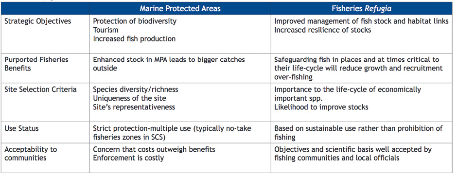
Natural refugia are, for example, features of the habitat which protect individual fish from being caught, such as canyons, boulders, crevices and overhangs, or mangrove forests (nursery habitat providing protection) for juvenile fish. As fishing effort and technology has improved and diversified, the amount and distribution of natural refugia has decreased. The primary difference between the traditionally defined MPA and refugia, is that MPAs are broadly focussed at protecting ecosystems and habitats, while refugia are chosen to be of relevance to life cycles of particular species, and they also have a focus on sustainable use rather than protection. Multiple use MPAs might also be categorized as refugia if they promote the concept of sustainable use (Pernetta et. al. 2010).
The definition of refugia as management tools is expanded to the following characteristics:
•Not be simply “no-take zones”,
•Have the objective of sustainable use for the benefit of present and future generations,
•Provide for some areas within refugia to be closed due to their critical importance [essential contribution] to the life cycle of a species or group of species,
•Focus on areas of critical importance in the life cycle of fished species, including spawning, and nursery grounds, or areas of habitat required for the maintenance of broodstock,
•Have different characteristics according to their purposes and the species or species groups for which they are established and within which different management measures will apply, and
•Have management plans.
Management measures that may be applied within fisheries refugia may be drawn from the following [non-exhaustive] list of classical fisheries management actions:
•exclusion of a fishing method (e.g.light luring, purse seine fishing)
•restricted gears (e.g.mesh size)
•prohibited gears (e.g.push nets, demersal trawls)
•vessel size/engine capacity
•seasonal closures during critical periods of fish life cycles
•seasonal restrictions (e.g.use of specific gear that may trap larvae)
•limited access and use of rights-based approaches in small-scale fisheries
Table 3: Short term vs long term objectives of resource and institutional related goals of fisheries refugia (Pernetta et. al. 2010).
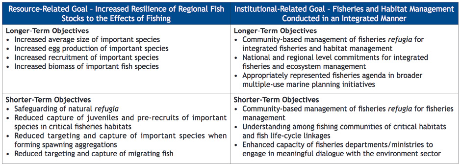
Table 4: Comparison between the objectives, benefits, site selection criteria, use and acceptability of traditional MPAs and fisheries refugia (Pernetta et. al. 2010).
GEF has supported interventions at local scales for securing valuable habitats for livelihoods and food security. An example is the GEF/UNEP South China Sea and Gulf of Thailand LME Projects. Experience in Southeast Asia, and in the Philippines in particular, suggested that no-take areas for fisheries were not well accepted by communities, and experienced problems of compliance. Between 2002 and 2008, the UNEP GEF Project Reversing Environmental Degradation Trends in the South China Sea and Gulf of Thailand (together with the Southeast Asian Fisheries Development Center (SEAFDEC) and member countries) developed and refined a concept of fisheries refugia, targeting mainly transboundary, demersal finfish and non-finfish resources. The concept is based on the fact that different habitats and areas are of critical importance during different stages in the life cycle of each species. The project developed a framework for a regional system of refugia in the SCS and GT, recognizing two sets of goals that related to 1) the resource and 2) to the institutional framework for management with an overall goal of increasing the resilience of fish stocks. Actual management measures would potentially include seasonal closures, fisheries management zones within multiple use MPAs, short term/spot closures, and closed seasons to safeguard spawning fish or reduce pressure on migrating fish. National activities were carried out by the departments or institutes of the government ministries of Cambodia, Indonesia, Malaysia, Philippines, Thailand and Vietnam. Guidelines for the acceptance of refugia as a management tool were accepted as part of the ASEAN-SEAFDEC Regional Guidelines for Responsible Fisheries in the Southeast Asian Region (SEAFDEC 2006). This provides a good example of how fisheries related regional organisations can be engaged by LME Projects (Duda 2014).
Experiences in the uptake of the fisheries refugia concept from the SCS + GT region that can be taken up by other areas include:
•Use concepts relevant to stakeholders
•Place an emphasis on sustainable use rather than prohibition of fishing
•Focus on fish life-cycle and critical habitat linkages
One constraint in the use of refugia as a management tool, is the lack of information about fish life cycles and their critical stages.
The South China Sea experience with the use of fisheries refugia can be referenced as an important example of one more tool that can be used as one of the complementary management strategies to support the sustainable use of marine resources and mitigate high levels of fishing pressure on small scale fisheries. It is also a useful tool for building partnerships and enhancing communication between the fisheries and environmental sectors, and in some way mitigates the adverse reaction to MPAs concept from fisheries communities, by emphasizing the sustainable use rather than the no-take concept. (Paterson et. al. 2013)


